The prevention and control of flash flood disasters in China has gone through four stages of development: "clarifying ideas and determining scales", "exploring solutions and accumulating experience", "prioritizing urgent needs and forming a framework", and "supplementing and improving to form a system". It can basically meet the needs of "early warning" and "forecasting" for flash flood disasters.
To minimize the loss of life and property caused by flash flood disasters, the subsequent construction of flash flood disaster prevention and control has entered the stage of "consolidating and upgrading, expanding and deepening", with a focus on enhancing the capabilities of "drill" and "preplan" for disaster response.
In the new stage, the construction of automatic monitoring stations for flash flood disasters must address the shortcomings of existing stations to truly meet the system construction requirements of the "Four Preventions" (forecasting, early warning, drill, and preplan) for flood control.
To this end, the Ministry of Water Resources has issued the Work Requirements for the Construction of Flash Flood Disaster Prevention Capacity Improvement Projects in 2022, which clarifies the construction requirements for flash flood disasters in the new stage.
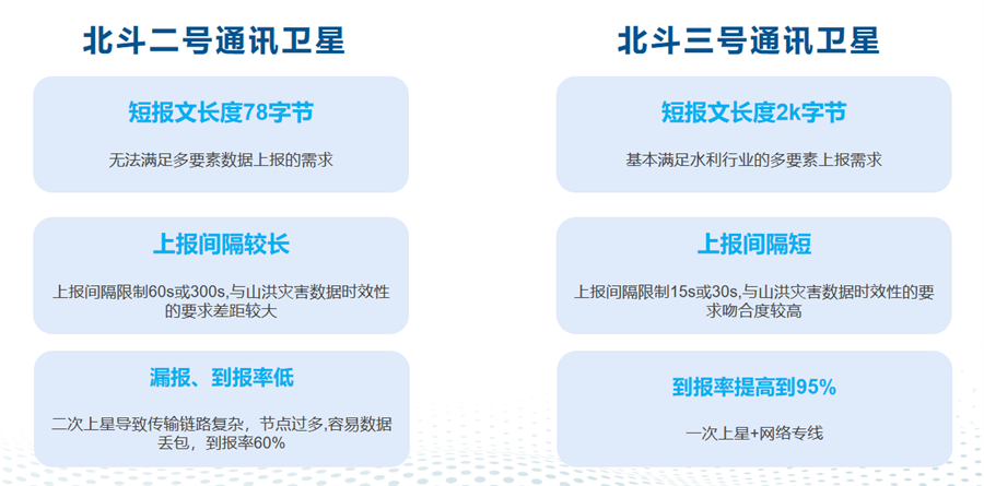
The launch of the Beidou-3 satellite has greatly addressed the application defects of Beidou-2 satellite communication in flash flood disaster early warning and monitoring stations.
Regarding the application of Beidou short-message communication in flash flood disaster monitoring stations, the functional comparison between Beidou-2 and Beidou-3 is as follows:
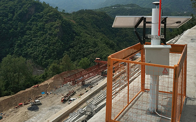
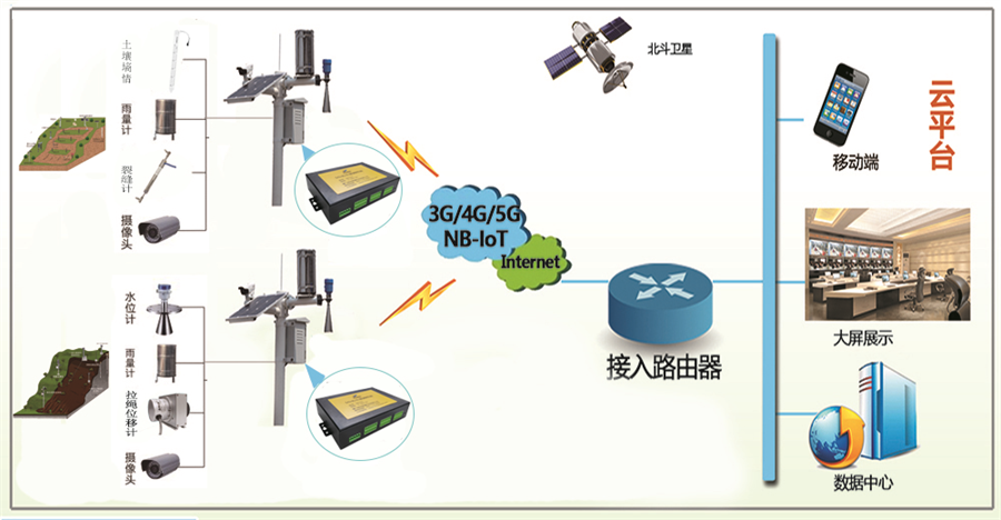
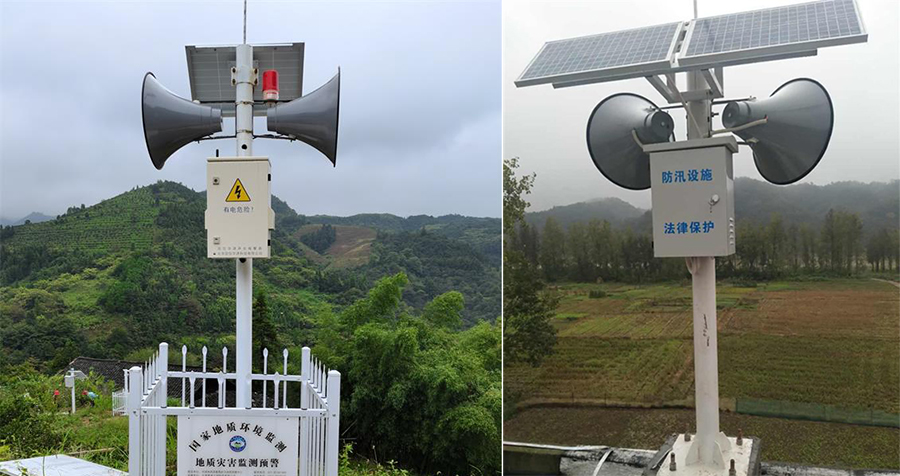
The flash flood disaster monitoring and early warning system is a comprehensive system with complete capabilities in prediction, forecasting, early warning, and emergency command. It mainly consists of a rainfall and water regime monitoring system, a wireless early warning broadcast system, and a video conference system.
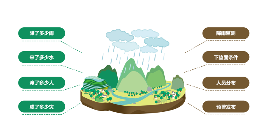
Integrating intelligent sensing products and platforms for water volume, rainfall, water regime, soil moisture, videos, images, meteorology, and remote sensing, the system analyzes and determines warning rainfall and dangerous rainfall levels. When rainfall exceeds the warning threshold, it issues timely early warnings to ensure rainfall conditions are detected promptly, early warning information is sent without delay, and the system "races against" flash floods at critical moments.
Real-time monitoring of various hydrological data is conducted through acquisition terminals. The collected data is then transmitted to the central flash flood disaster monitoring and early warning platform via wireless communication terminals. The platform conducts comprehensive analysis of the obtained data to generate early warning information, which is finally released by the wireless disaster mitigation release system.
This system enhances the capabilities of flash flood disaster monitoring, early warning, forecasting, and rapid emergency response for disaster relief. Geological disaster monitoring can be divided into four layers: the Perception Layer, the Network Layer, the Platform Layer, and the Application Layer.
It monitors the status of sensors for various monitoring parameters in real time, including front-end sensing devices for groundwater level, soil moisture content, soil pressure, rainfall conditions, etc.
It supports data communication with bidirectional (upward and downward) transmission capabilities, and is compatible with multiple communication methods such as wireless cellular networks, SMS, Beidou, PSTN, ultra-short wave, and ZigBee. The sensing device M21F2 can transmit data upward to the monitoring and control center platform via the communication method of the monitoring and early warning platform.
It integrates equipment and system functions across all layers. Through signal connections, it issues commands from the platform to front-end sensors, and implements the collection, processing, storage, and analysis of uploaded monitoring data, while achieving real-time linkage with major front-end monitoring devices.
It enables information release channels and displays information data and early warning information in real time.
The flash flood disaster monitoring and early warning system is developed based on key technologies such as the Beidou satellite communication backup channel, high-resolution remote sensing data, and advanced calculation models.
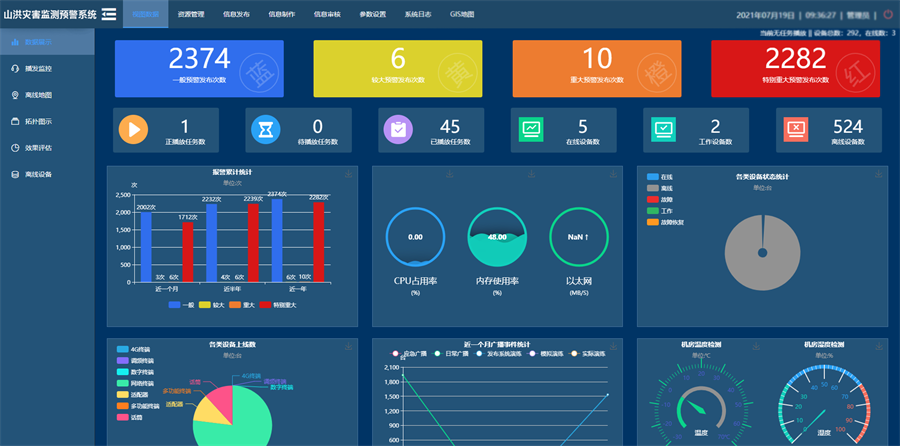
The system supports a cloud platform and can realize functions including disaster early warning analysis, rapid assessment of disaster losses, real-time data update, output of statistical reports on analysis results, and creation of thematic maps.
By combining virtual reality technology with 3D visualization technology and conducting flood simulation demonstrations, it achieves flash flood monitoring and early warning based on real scenarios. It is a complete solution integrating monitoring, early warning, analysis, query, emergency response, feedback, and statistics.

It mainly includes functions such as retrieval, query, addition, modification, deletion, and data import/export for basic information of counties, townships and villages, basic information of small river basins, basic information of monitoring stations, county-township-village prevention and control plans, historical disaster information, and basic project situation information.
The rainfall and water regime monitoring and query function monitors the rainfall and water regime in real time mainly through WEBGIS and tabular forms, and conducts query and statistics on rainfall and water regime information. The system is divided into four parts: rainfall and water regime alarm, rainfall monitoring, river water regime monitoring, and reservoir water regime monitoring.
It can provide meteorological information such as real-time weather and forecasts, real-time rainfall information, real-time/historical typhoon tracks, and real-time satellite cloud images. It also offers basic information and monitoring data of hidden danger points (e.g., landslides, mudslides). Meanwhile, it conducts predictive analysis of rainfall and stores the results in the database.
It includes functions such as display of early warning information and status, internal early warning, external early warning, early warning feedback, query of early warning records, and display and modification of early warning indicators.
After the early warning release subsystem issues public early warnings, the emergency response subsystem is activated automatically. This subsystem provides decision-makers with detailed and complete workflow for flash flood disaster response. When a disaster occurs, the system offers accurate disaster location, detailed maps of various evacuation routes, and query service for response lists. To address the threats to people's lives and property caused by flash floods, the system also provides plans for various rescue measures and self-rescue measures, and offers real-time feedback on the implementation effects of these plans.
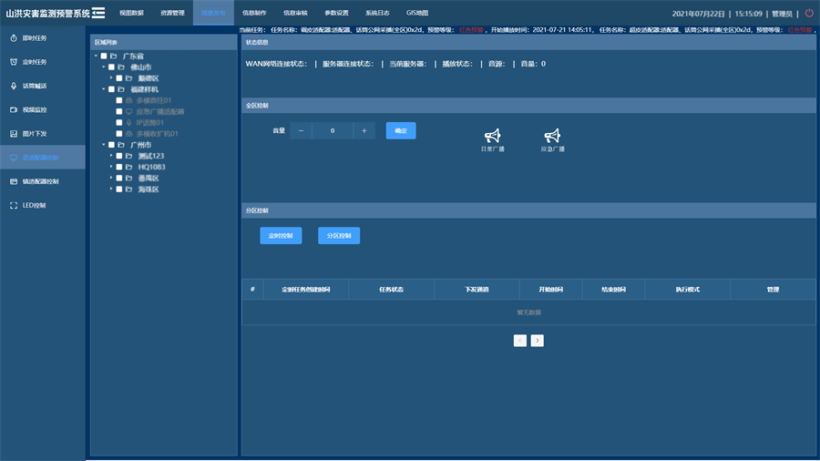
It can realize the interconnection of information and the unified deployment of personnel and materials through the video conference system and the mobile emergency command system.
It centrally displays the information concerned by users in one window. Users can make personalized settings, realize the display and analysis of different data such as rainfall and water regime information, flood forecasting, and meteorological and land resources data as needed. It uses a single map for work guidance, completes the overall workflow of flash flood disaster early warning, and realizes relevant business functions and information management.
Wide-Area Coverage: The flash flood disaster early warning broadcast system adopts multiple transmission methods such as IP network and wireless mobile network for data and voice communication. It ensures the coverage area of early warning signals and has strong adaptability to terrain environments. Basically, flash flood emergency early warning broadcasts can be transmitted wherever mobile phones can make calls.
Always Online: The system can ensure long-term and safe operation. Once the wireless early warning broadcast application is activated, it will remain online, and the device status can be monitored in real time through the cloud platform.
Real-Time Release: The flash flood disaster early warning system can realize multiple broadcast methods such as text, SMS, and telephone dialing. It supports functions such as scheduled broadcasting and emergency broadcasting, enabling the release and reception of information anytime and anywhere.
Ease of Operation: The on-site hardware equipment is simple to operate. As long as there is a wireless information network, the flash flood emergency early warning broadcast terminal can be used by connecting to a power source. The software interface is easy to operate and learn, making it suitable for environments such as mountainous rural areas.
Power Supply Guarantee: The equipment is equipped with a 12-volt power supply battery. In case of local power failure, the battery can be used for direct power supply. At the same time, solar energy can be used to power the terminal, which is environmentally friendly and safe.
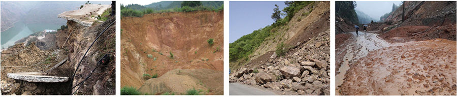
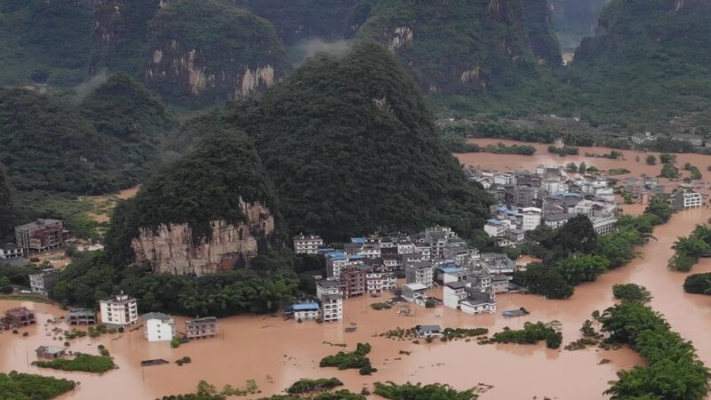
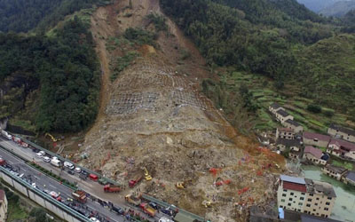
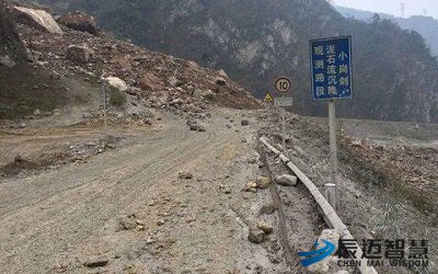
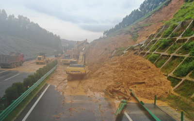
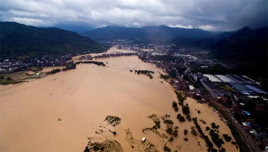
Flash flood disasters are natural geological disasters with great destructiveness. At present, people can only use certain early warning strategies to minimize the probability of flash flood outbreaks, but cannot fundamentally prevent the occurrence of this disaster—especially in hilly areas.
The application of the flash flood disaster monitoring and early warning system enables the prediction of the timing of flash flood disasters in advance, striving to gain time for the people to evacuate. This ultimately achieves the goal of protecting the lives and property of the people.
The development of the Internet of Things (IoT) technology further ensures the safety of people's lives and property, and makes significant contributions to the economic development of hilly areas in China.